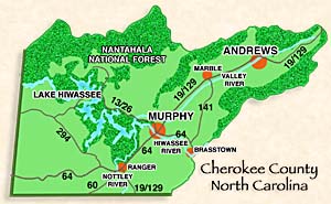
Murphy • Andrews • Brasstown • Peachtree • Ranger • Marble
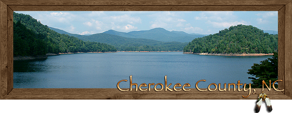
Cherokee County Western North Carolina
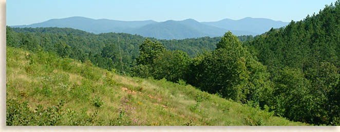
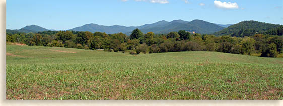
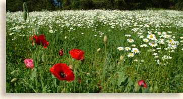
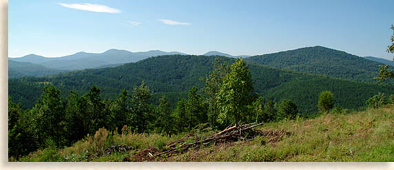
Clusters of mountains collide along the western wall of the Blue Ridge Mountains below the southern shoulder of the Great Smoky Mountains. Long and broad valleys gather rivers and waterways together creating a path whose watersheds flow beyond the western horizon. Steep ancient mountains reach to the sky like rugged stair steps to the heavens. Elongated mountain ridges force narrow peaks out of their crest like that of the red timber wolf's powerful jaw protecting its rightful domain. |
Cherokee County North Carolina, in the far western reaches of Western North Carolina is a haven of mountains, valleys, rivers and lakes, offering outdoor adventure to all ages. The county is dotted with historic towns and ancient sites longing to be explored. Mountain ways still survive here at a renowned folk school that has been influencing and inspiring thousands for nearly a hundred years.
Cherokee County was one of the last strongholds of tribal lands belonging to the Cherokee Nation before their final exodus west along the tragic "Trail of Tears." These native lands still echo the language of the Cherokee people in the names of landmarks, waterways and districts. The high mountains of the Nantahala National Forest border the horizons to the north and east, with Tennessee's Cherokee National Forest to the west and parts of North Georgia's Chattahoochee National Forest to the south.
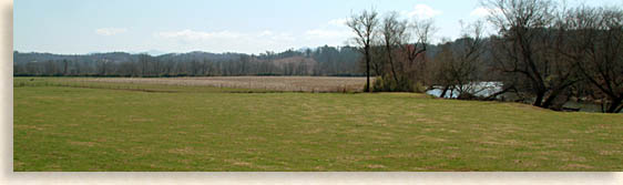
Three rivers traverse the county's valley floor, joining together at Hiwassee Lake before making 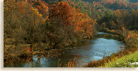 their journey to the western valley lands below. The Nottely River flows northward from neighboring Union County, Georgia. The Hiwassee River flows northwest across Cherokee County, finding its headwaters in the northeast corner of North Georgia's mountain country's western divide. The Valley River, which originates in far eastern Cherokee County, flows westward across the mountainous valley regions uniting with the Hiwassee River before merging into Hiwassee Lake in the northern section of the county. This diverse northern backcountry offers an exciting outdoor adventure escape for those looking to getaway from the congested world out into the open spaces.
For the outdoor enthusiast there's camping, hiking, biking, boating, water sports, canoing, kayaking and fishing, along with plenty of white water adventure close by and did I mention scenic driving tours?
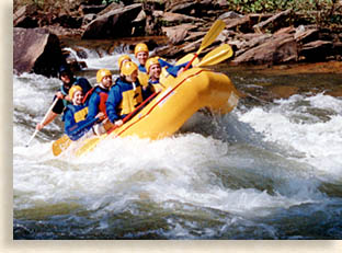
Cherokee County is situated between two major white water river gorges. Just outside the west end of the county is Tennessee's wild Ocoee River Gorge. At the eastern end of Cherokee County is the legendary Nantahala River Gorge with both a lower river gorge for white water rafting and kayaking, plus an upper river gorge ideal for fly-fishing with a waterfall canyon setting that you won't believe.
For those who enjoy the more leisure atmosphere, there are picture book mountain towns and communities offering charm, hospitality, shopping, dining and lodging along with numerous historical landmarks marking the scene for Cherokee County's earlier days.
Cherokee County is the last and by no means the least of Western North Carolina's counties, the region is considered a natural gateway to the west, or for eastward bound travels its an access to North Carolina's high country.
The county was established in 1839 as the door closed on the Cherokee people who were given lands west of the Mississippi in accordance to the Treaty of the New Echota, signed in 1835 by the United States government and a small faction of Cherokee leaders.
Settlers quickly migrated into the region claiming their new lands by lottery, taking up where the Cherokee left off, temporarily living in some of their homes and harvesting fields planted by the former residents. Most of the new arrivals came from Pennsylvania, Virginia and Tennessee. These early settlers were not the first old world visitors or their descendants to visit the area. Historical markers throughout the county tell their tales and lay their claims to local events, historical events the Blue Ridge Highlander will explore in this Cherokee County profile as we visit each region.
Of our many outlets of choice throughout Cherokee County's towns, communities and local attractions we will begin with the historic county seat of Murphy, North Carolina before reaching into the high country and the valley towns along the local river basins.
Murphy the County Seat
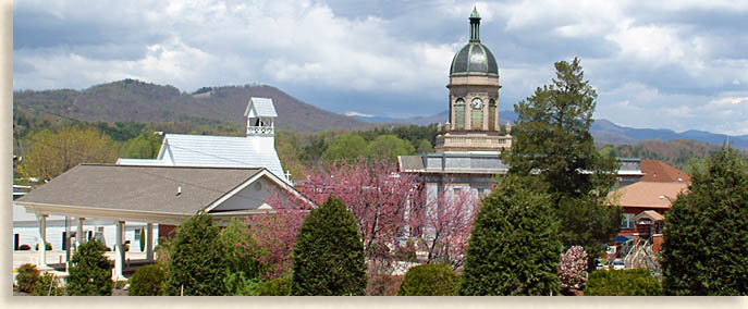
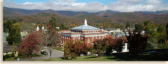
The town of Murphy is a charming and picturesque mountain town that anyone would be proud to call their home. Situated here in the center of the county on a hilltop at the convergence of the county's two main rivers, the Hiwassee River and the Valley River near the highway junction of US 19/129/74 and US 64. The town was named after a North Carolina legislator named Archibald Murphey; a misspelling of his name became the town's present identity.
Originally the town was called Huntington after Colonel H.R.S. Hunter who established a trading post and post office here in 1835. The county itself was formed in 1839 from a portion of neighboring Macon County, yet the town of Murphy wasn't officially incorporated as the county seat until 1851.
Though it is just one block off the main crossroads in downtown Murphy, the historic blue marble courthouse displays a presence of dignity and prosperity the county has always aspired to. The workmanship of the courthouse's exterior is composed of a regal eloquence that is quite captivating in its architectural design. This blue marble structure was constructed from local "high quality" marble quarried in the Valley River region to the northeast. The courthouse standing today was completed in 1925 at the height of the local railroad boom and it has been placed on the National Register of Historic Places.
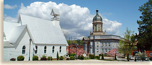
Across the street is the beautiful and brilliantly white painted Episcopal Church of the Messiah, built in 1895. The church stands directly across from the courthouse, you can see the direct contrast in church and government, but here it finds symmetry in an abstract statement of, "the law is the law no matter what side of the street you are on."
 Facing east at the main street cross roads you can't help but notice the strong and stately First United Methodist Church, it was constructed as a modified "Modern Akron" in 1922. The broad main streets at this downtown intersection are lined in historic buildings. The scene depicts a time when life was much simpler; the nation was young, and growing strong and the downtown district was the central life force for the people in the community.
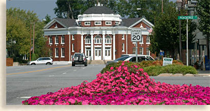
Today Murphy is a friendly small town with big ideas and has brought that synergy back to life revitalizing the downtown area as well as many other areas of town. Not only in the historic downtown district, but also throughout the town you will find a nice blend of unique shopping.
From April through October downtown Murphy is the home of Cedar Valley Farmers' Market, operating every Saturday from 10:00 am to 2:00 pm. Local growers come together to sell excellent quality organic produce and baked goods as well as the best perennial plants around. The market also hosts local musicians creating the atmosphere and artisans selling their paintings, pottery, jewelry, handmade furniture and other goods.
One of the many special features of Murphy is the fairly large selection of creative eateries, casual pubs, and family restaurants. As well as fine dining establishments with creative and gourmet menus you won't find in most small towns, and the best part is the prices are very reasonable. So whatever your particular craving is, you will find a variety of delectable entrées and treats to your delight.
Amongst the many great old historic homes and structures in the Historic Downtown Murphy District, you'll find the Robert Lafayette Cooper House, a Queen Anne Victorian built in 1875. The house has been placed on the National Register of Historic Places.
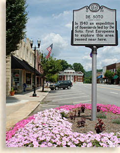
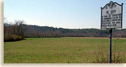
Here along these historic streets are plenty of sights to be seen and some sights that are unseen. Several historic markers line the curbs along the main streets of downtown Murphy. One most significant marker is on the northeast corner of Tennessee Street and Valley River Avenue. The marker reads, "In 1540 an expedition of Spaniards led by De Soto, first to explore this area passed near here." Those were the first European eyes to see this region, an interesting fact we'll cross again later in this feature story on Cherokee County.
Heading about two blocks further south along Peachtree Street is another historical marker that reads, "Juan Pedro, In 1567 an expedition of Spaniards, set out from Florida by Pedro Menendez De Aviles and led by Juan Pedro passed near here." At the downtown intersection of Peachtree and Hiwassee Street yet another marker reads, "Cherokee War, Major George Chicken of South Carolina, led first English Military Expedition against the Cherokee in this area 1715." Apparently new folks have been visiting the Murphy area for nearly 500-years, that's impressive.
 The one historical marker that seems to be missing is one for the patriot and courageous leader General Griffith Rutherford who led an expedition in 1776 of 2,400 Continentals over the Swannanoa Gap (just east of Asheville) heading into the deepest reaches of Western North Carolina to put down a Cherokee uprising spurred on by the British against the patriot colonials who were at war with King George of Britain for independence.
It is said he established his headquarters here at today's town of Murphy, while he organized his North Carolina frontiers men and joined forces with nearly as large a force of men that came up from South Carolina. Their mission was to crush the Cherokee, some of which were raiding settlements in the eastern Blue Ridge Foothills country of North Carolina. At hearing and seeing of the size of this force, the Cherokee took their families and headed into the forest for protection due to the massive amount of firepower Rutherford's men were willing to unleash on them in retaliation for the massacres of frontier settlers. The route of his campaign against the Cherokee blazed a trail that would become several of today's major highways through these Western North Carolina Mountains accomplishing it in a record amount of time. This route is known as Rutherford's Trace.
Next door to the Cherokee County courthouse is the Cherokee County 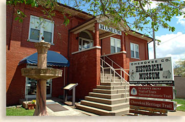 Historical Museum located in the historic red brick Carnegie Library building. The curator would like everyone to know that the museum is now handicap accessible and fun for the entire family.
The museum houses both the Cherokee County Historical Museum, an Interpretive Center for the Cherokee County Trail of Tears and a hub for the Cherokee Heritage Trail. The history displayed at the museum reflects the local community heritage of its cherished mountain folks along with local Cherokee residents whose ancestors have called Cherokee County home since prehistoric times. The Trail of Tears National Historic Trail is being presented at the museum in its own exhibit as well as an exhibit on the Unicoi Turnpike National Millennium Flagship Trail. The Unicoi Turnpike also known as the Trade Path, Northwest Passage or the Unicoi Gap Trail, was one of the most used ancient routes through the mountains connecting the lands to the east beyond the mountains, with the Cherokee Overhill Towns in the Tennessee River Valley to the west.
Up on the hilltop in the historic district of Murphy is the old Harshaw Chapel constructed in 1850; in Greek revival style. This historic church is visible from the courthouse to the left of the white Episcopal Church across from the courthouse.
The Harshaw Chapel is no longer used today by it's original congregation's descendants and newly received members. They moved over to the historic First United Methodist Church at the end of Valley River Avenue. Today, Harshaw Chapel is in the caring hands of North Carolina's Society of the Daughters of the American Revolution. A lot of history has taken place here within this hallowed hall, with much of its historic past still remaining in the cemetery next to the chapel.
One local celebrity and controversial figure at rest in Harshaw Chapel graveyard is a man named Abraham Enloe. Abraham was said to have in his hire a servant girl named Nancy Hanks. I first heard this story while doing a profile on Rutherford County, North Carolina.
It is the same Abraham Enloe buried in Murphy, that's mentioned in Rutherford County. Members of the Friends of Abraham Lincoln Birthplace are petitioning for his DNA to prove he is the true father of Abraham Lincoln. I found this to be an interesting story, especially the claims concerning the facts within President Abraham Lincoln's biography and the historian hunter's claim, I do have a hunch of my own but that's too much to go into here and now.
On the north edge of the old historic downtown district, is Konehette Park. Konehette is the Cherokee word for "valley." The park runs along the Valley River as it makes its way through town. The new Wellness Center and Pool located in the park are a welcomed addition to the town of Murphy for residents and visitors alike.
One of the unique geographical features of Murphy is its location where the Valley River merges with the Hiwassee River at the mouth of a foothills' gorge. Due to this geographic feature, The Heritage Partners have extended the river park trail around the river junction to the other side of the historic downtown district creating a loop through downtown and back to the park along its historic residential neighborhood, a great way to enjoy the beauty of the river and downtown Murphy. The river-walk trail is currently completed to the Depot and the trail leads you across a foot bridge over the Valley River. The trail along the river-walk will take you past blossoming trees in the spring with natural rock outcroppings making it a nice stroll through the park any time of the year.
Going southward from downtown Murphy on Hiwassee Street, at the bottom of the hill along the river's edge is the historic 1887 L & N Depot. Though a rail line had been planned to reach Murphy since 1855, it didn't officially arrive until 1888 due to delays. The first delay was caused by the Civil War, then the bankruptcy of the Western North Carolina Railroad Company in 1866. The railroad company started once again in 1877 finally reaching Murphy in 1888.
Once the rail line was finished it opened the region for the commercial export of natural resources such as lumber, iron ore, marble along with other minerals and local goods. The rail line brought new arrivals to the region as well as bringing in needed outside goods and luxuries. Although the railroad no longer travels through Murphy, this rail line began an era of prosperity in the town of Murphy that is still enjoyed today.
The bridge from the old rail line that crossed the Hiwassee River is gone with the exception of the original stone pile-on supports standing in the river and some of the old rail line tracks are still in place. There still remains several of the old rail line warehouses near the depot, some restored or remodeled, others awaiting the process. The L&N is a great sight for railroad buffs and the bright red caboose makes for a good photo opportunity.
Set high on a hilltop on the opposite bank of the Hiwassee River to the southwest above the peninsula of today's downtown Murphy, once sat the early 19th century Fort 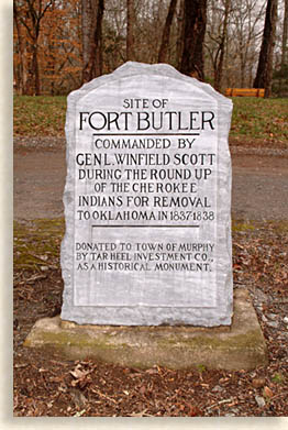 Butler. Its sole purpose was to process the local Cherokee who had been rounded up for removal west to Oklahoma. It was called the Indian Removal Act by Congress, putting General Winfield Scott in charge of 7,000 troops to aid him in collecting the Cherokee who didn't want to leave their homelands and escort them with force if necessary, westward along the infamous "Trail of Tears." This was not a glory assignment for the general, forcing these people from their homes didn't sit well with him; although he carried out his duties just the same. The few Cherokee leaders who signed the new treaty went ahead of the main body of Cherokee being removed. With "gold" being discovered in North Georgia and the State of Georgia willing to use its own prejudicial force if necessary, these individuals and others who supported the treaty decided it was best to "go west" rather than taking a chance of total extinction under the threat.
Too many of the Cherokee died along the way due to poor planning on both the government and some Cherokee leaders' behalf, with the government pushing the urgency to meet the treaty removal deadline along with inhospitable weather, a long dry hot summer followed by a very wet and cold winter. Many of the Cherokee perished from broken hearts alone, grief stricken just waiting to collapse along the torturous journey. It's a tale the Blue Ridge Highlander will tell in full one day, hopefully soon.
All that is left of Fort Butler, constructed in 1837 is a stone marker. The property is privately owned now, a small park setting has been landscaped and an engraved stone marker identifies the site. Looking northward from the site of Fort Butler, you can see the junction were the two rivers meet before entering the bluffs and gorge regions that begins at the southern end of Lake Hiwassee.
Cherokee Legend
Though the town of Murphy is seated in an ideal  picturesque location on a hill at the mouth of a foothills gorge, it was never a permanent town site to the Cherokee, it was never conducive to their daily needs. Near the convergence of the Hiwassee and Valley Rivers, at the northern end of the town of Murphy, the Cherokee believed there lived a legendary river monster they called "Tlanusi'yi," the Leech Place.
Just above the junction of the two rivers along the Valley River is a deep hole where a large stone ledge runs across the water flow. The Cherokee used the ledge as a bridge until one day some men were going along the trail and saw a great red object as large as a Cherokee house lying on the rock ledge in the stream. As they watched it began to unroll, stretching itself along the rock until it looked liked a great leech with red and white stripes along its body.
After watching the beast roll up and stretch out once again it crawled down the rock disappearing into the waters of the deep river hole. They said the water began to boil and foam when suddenly a great column of white spray was thrown high in the air and came down like a waterspout onto the spot where they were standing, fortunately their curiosity turned to fear as they ran from the place before the water struck. They say that at times native bodies would be found along the banks that they thought had been swept off the rock and pulled under the water. When examined the bodies would be missing their ears and nose. The people stopped crossing the rock bridge and avoided the place they called, "Tlanusi'yi," the Leech Place.
Rivers are considered powerful places by Native American's, especially where two merge, maybe the giant leech legend was used to keep some of the Cherokee away for a more secretive reason, or maybe its appearance was meant to be a bad omen of things to come, such as the tragedy at Fort Butler.
The Cherokee did live all along the Hiwassee River valley regions as well as the Valley River region and other valley river areas throughout far Western North Carolina; they just didn't live at this river junction.
The Cherokee towns along the county's waterways were called the "valley towns." The Cherokee were not a nomadic people; they built primitive homes and created permanent towns for the most part. Today many of these same ideal settings are called Cherokee County's towns and communities. Some believe these valley lands have been settled, hunted and harvested by local Native Americans for thousands of years. We'll begin our next phase of our feature on Cherokee County following the Hiwassee River to the town of Peachtree.
Peachtree
Several miles east along the winding Hiwassee River on US 64, is the town-community of Peachtree. This beautiful valley river country is bordered to the north by the Snowbird Mountains, to the northeast by the River Valley Mountains, to the northwest by the Unicoi Mountain range, and to the southeast along the distant horizons is a view of North Georgia's crown, Brasstown Bald.
Peachtree today is a quiet community with several local businesses along US 64 at the junction of highway 141. The Tri-County Community College is located here as well as the Murphy Medical Center. There are a couple of shops and the restaurant is a pleasant addition.
At the founding of Cherokee County in 1839, it was believed that the Peachtree area would be the most likely place for the new county seat, the land was more conducive to building and the water was good and plentiful. The town of Murphy sits on a hilltop at the convergence of the Hiwassee and Valley River in the mouth of the Hiwassee Gorge, making the central part of the town's future expansion more difficult.
In 1851, it was decided to make Murphy the county seat due to its crossroads at the river junction, making it more accessible for all the county's government business. What Peachtree and Murphy do have in common is they share the same riverbank and post office and zip code though they are separate by several river and road miles.
 There are three historical markers within the county seat of Murphy dating from 1540 to1715 A.D. that read at the end, "passed near here, or in this area." Peachtree would be the area they would have passed through or came to. At the convergence of the Hiwassee River and Peachtree Creek, is the historic archaeological site of an ancient Cherokee town called Guasili; a historical marker on the south side of US 64 marks the area. This marker reads the same as the historical marker located in Murphy concerning De Soto.
Though Hernando De Soto remained with his main body of men in the foothills of the North Georgia Mountains, he directed smaller exploring parties into the mountains to search for gold. Historical records show numerous mentions of Guasili in De Soto's journals, that the people of Guasili graciously welcomed and entertained the Spaniards explorers looking for gold.
History is rich in Cherokee County though not much gold was ever discovered. The big gold strikes in the Blue Ridge Mountains lay along outer southeastern regions of this vast mountain country, where the base rock of the mountains are estimated to be substantially older than the interior and western ranges of the Blue Ridge Smoky Mountains.
What archaeologists did find here at this site was a low and ancient man-made mound they believe dates back to the Archaic period (8000 to 1000 B.C.) So important was this find, that in 1933 a research team from the Smithsonian worked the dig uncovering nearly 250,000 pieces of pottery along with 68 burial sites enclosed in stone-lined graves. Early Native American's constructed earth mounds for either burial or ceremonial purpose, the Smithsonian report concluded that this mound was a multi-level ceremonial structure. Some evidence at the site was inconclusive due to damage from an earlier dig in 1885, possibly treasure hunters or Indiana Jones amateurs.
Earthen mounds like this are scattered all over the valley floors of the Blue Ridge Smoky Mountains all the way through the Mississippi River Valley regions, and they come in various sizes. The Kituwah village mound located just east of Bryson City in Swain County, North Carolina, some believe it to be 10,000 years old or possibly older. The Cherokee people call the area Kituwah "the mother town," site of their origins as a native people. The Peachtree Mound is on private property not a public site. It can be seen from the historic De Soto marker if you know where to look.
Historic and present times show Peachtree is an ideal region for living. The summers and winters are mild here due its southern location in the Blue Ridge Mountains' climate belt. High mountains surrounding the Peachtree region create a natural barrier, annual rainfall and local waterways; irrigate the fields and meadows of its valley lands. The ancient natives loved the area and so do today's locals and visitors.
Here along old US 64 on the east side of Peachtree is a historical marker identifying the site of the first white settlement in the region predating the founding of Murphy in 1839. The marker reads, "Baptist Mission for Cherokee Indians established in 1817 consisting of a chapel, school, farmland and mills was 31/2 miles north."
Just east of Peachtree along the western bank of the winding Hiwassee River along US 64, on the southeastern edge of Cherokee County is the old Valleytown's Baptist Mission Farm founded in 1820. Here the American Baptist Foreign Mission Board founded a church along with a boarding school and a model farm. Their purpose was to civilize and to Christianize local Cherokee families. The site is now both serene and beautiful with a long river valley stretching across the horizon and with mountains lining its edges, one of the prime spots within the entire county.
Many of the Cherokee people chose to assimilate to the new nation's technology and educational advantages in order to live a more harmonious and prosperous life amongst the whites, "when in Rome" so to say. The U.S. Government and missionaries were usually willing to bridge that cultural gap. After struggling with cultural difference in language, Evan Jones a teacher at the mission school decided to first learn the Cherokee language. Next, through the use of the recently developed the Sequoyah Syllabary writing system, created by a Cherokee mixed blood called "Sequoyah," Jones decided to combine both efforts creating an alternative teaching system. By this innovative process the Valleytown's Baptist Mission's School became the most successful of the Protestant mission schools throughout the Cherokee Nation. Today, the Mission Farms still operates as an agricultural farm along this rich river bottom country and is privately owned.
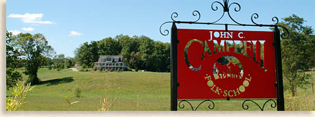
John C. Campbell Folk School
Education seems to be contagious in this region, must be the valley river water or fresh mountain air. Towards the southern end of this valley is the John C. Campbell Folk School in Brasstown, North Carolina, located along the southeastern edge of the county at the junction of Old Hwy 64 and Brasstown Road.
John C. Campbell and his wife Olive Dame began to study mountain life from West Virginia to North Georgia at the beginning of the 20th Century. While on their journey, John focused on interviewing local farmers about their farming practices. During the same time Olive studied regional handicrafts, collecting mountain ballads for study and preservation. Both of them were highly influenced by an educational system they were exposed to in Denmark, where the community focused on transforming their countryside into a vital and creative force.
They felt they needed to start a "folk school," meaning "school for life." Its mission was to help Appalachian folks who needed to change a life pattern that caused intelligent young folks to leave their families to obtain work in the cities rather than applying new techniques to improve life in the mountains.
Unfortunately John never saw his dream come true, he died in 1919. John's wife Olive, along with their good friend Marguerite Butler carried on their studies of folk schools in the regions of Denmark and Sweden along with other countries before founding the John C. Campbell Folk School in Brasstown North Carolina in 1925.
The 372-acre folk school campus is situated in a natural rural farm setting that hasn't changed much in nearly 100 years. New school buildings specially designed for the settings stand alongside historic structures dating back to its first "nail and board" or rather "joist and peg." The most recent building structure the "Field House" was built in the true "green" construction method.
The setting at John C. Campbell Folk School is miraculous; rather than having the buildings and structures all clustered together, they are spread out like a farm village along tree covered trails following the natural flow of the landscape, with marked pathways that leads to the different class buildings. The nearly 100-year old atmosphere at the folk school isn't a matter of a period in history but a mind set in what's natural and unimposing.
The best place to begin a tour of the campus is at the historic Keith House (built in 1927) at the entrance to the campus. It doesn't matter which of the two trails you take, the trail is a loop that will lead you through a wooded village setting past classroom and recreational buildings like the History Center, Olive D. Campbell Dining Hall, Davidson Hall, Francis Whitaker Blacksmith Shop, Willard Baxter Wood Turning Studio, Jewelry and Enameling Studio and the Clay Studio to mention a few. At the furthest of the trail is the big festival barn and blacksmith row near the back of the property at Folk School Road.
Wide-open fields surround the other sides of the campus with exceptional mountain vista to the north, south and east. The Little Brasstown Creek flows through the property, part of the Rivercane Walk on the farm campus for nature lovers. All the lands southeast of here consist of rural homes and old homesteads along with new homes and developments divided by pristine farms and meadows, this district is called Martins Creek.
Today, the National Register of Historic Places designates John C. Campbell Folk School, as a Historic District. The campus contains over 30 buildings housing studios and classes in pottery, weaving, spinning, dyeing, quilting, doll making, basketry, broom making, wood working, wood carving, stained glass making, blacksmithing, painting, dancing, jewelry making, organic gardening to mention just a few. You can even make your own dulcimer instrument and learn to play it. The school has a large class catalog listing all the opportunities available, published twice a year, or better yet, save a tree and visit their web site; all of their classes are listed on-line. The folk school also has on-campus lodging and an incredible dining hall with wonderful food for the complete village experience. The dining hall is not open to the public its for campus use or certain folk school events only.
The good news is that the folk school is open to the public for visitors to respectfully tour the grounds as well as for week-long and weekend classes. Many visitors coming for classes enjoy residing at the folk school, living the good life away from the stresses of everyday pressures, a great way to get in touch with the creativity within us all. The folk school is one of Mr. and Mrs. Highlander's favorite places to visit. The atmosphere there is always serene; the air is fresh, no city lights, no pollution, it's just peaceful, creative, educational and good mountain fun. John C. Campbell draws instructors from around the country as well as their resident instructors, always offering new experiences with each new class schedule. I believe these visiting instructors are also looking for their share of that great mountain magic to take back home with them.
The one thing we've noticed is that when unskilled students arrive they're in awe. When they leave, their totting a big smile and the door prize they created themselves with their own hands, taking pride in what they have accomplished at the folk school. They can also take home a change of spirit and a fresh outlook on life in general. Meeting new people of all ages in this unique educational environment is a great way for an individual, a couple, or the whole family to experience a vacation retreat, something unique and bonding.
There's a wonderful gift shop on the campus called the Craft Shop, selling some of the arts and craft-works made at the school by both instructors and students...this is real hand-made in America stuff.
When it comes to festivals the folk school leads the way in Cherokee County with live music, traditional dances, arts, crafts, exhibits and good food. Their Fall Festival is the largest festival in the county and surrounding region, its something you won't want to miss.
Brasstown
Just outside the campus grounds of John C. Campbell Folk School, is the town of Brasstown. I'm not sure its a real town, its not as big as a town, it doesn't weigh as much as a town, its best described as a modest "artisan village," but smaller. I joke only because Brasstown is a must see destination when you're in the area. Several shops and galleries line one side of the road facing the folk school campus at the junction of Old US 64 and Brasstown Road.
To be fair, Brasstown is an actual town in a rural farm community with its own post office making it official. Oh wait; they also have a late model gas station or should I say "filling station" with a small store for snacks and drinks. The claim to fame here is their "Annual New Year's Eve Possum Drop." Don't worry no possums are hurt. If you are in the neighborhood next New Year's Eve, stop by and enjoy the fun.
The folks who live in Brasstown are good-hearted mountain folks and always have been. The local Brasstownians were so impressed with Olive Dame, John C. Campbell's wife's proposal to build a folk school in their area, that they pledged building materials, labor and other support along with 75-acres of land donated by the Scroggs family in 1925 to the project.
The historic yet modest stores in Brasstown that once provided basic goods to the community have today become art galleries, craft shops and a local natural food shop as well as a community garden spot. The modest district of Brasstown adds color and nuance to the region and is the perfect accent to the folk school, rounding out a kinship that has lasted nearly a 100-years.
Brasstown is a delightful little spot almost in the middle of the road with a mountain charm that speaks for itself and friendly folks to pass the time with.
Valley River Country
In the northeastern region of Cherokee County along US 19/129 near the town of Andrews, there is a long open valley floor that appears to be almost perfectly level against its towering mountainous horizons. A phenomenon when you consider this is in the midst of a land where nothing is flat. The valley is encased within long mountain walls on either side that seem to rise straight up to the clouds as each mountain range races to meet at the valley's end. To the south are the towering Valley River Mountains; to the north the rolling Snowbird Mountains, both mountain ranges are part of the Nantahala National Forest.
The Valley River snakes it way along this broad valley floor on its way westward to converge with the Hiwassee River at the 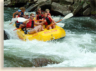 town of Murphy. The Cherokee called this place "Gunahita," meaning long and later changed it to "Konehetee," meaning valley.
The 4-lane highway (US 19/129) with its wide medium dissects the center of the valley floor offering outstanding views of the valley from the roadway. The shoulders of the roadway are often lined with wildflowers spring, summer and fall. The Valley River region's older two lane roads along the valley generally hug the long mountain ranges on either side, winding along the valley edge, offering only views of the mountains across the way. At the point where the mountains meet at the eastern end of the valley, the four lanes becomes the two lanes of US 19/129 due to the two mountains range narrowing at the eastern end of the valley. Here the roadway between the giants mountain walls continue their race along either side as the roadway gradually gains altitude up a rather straight path to the low mountain gap in the community of Topton, this is the east end of Cherokee County, beyond here to the east you enter the deep Nantahala River Gorge country.
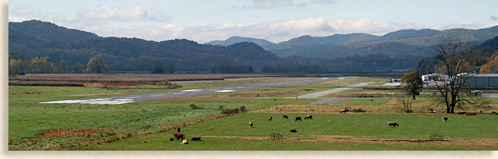
In the central section of the Valley River along the four-lane you'll find the Western Carolina Regional Airport along the north side of the valley. The runway is 5,500-feet in length and capable of handling small jet engine planes or if you prefer aircraft. On the south side of the highway across from the airport is the valley town of Andrews, North Carolina.
Like Murphy, the town of Andrews has a wealth of history along with interesting turn of the century architecture for an "out of the way" mountain town. Andrews was not incorporated until 1905 and didn't really get its start until 1890 when the railroad was completed at present day Andrews. During that time this depot stop was called Valley Town until it took its name in honor of the railroad's second vice-president Colonel A. B. Andrews.
What makes the town of Andrews so special is that it has a nice laid-back, feel good mountain town atmosphere with a backdrop I can only call, "outstanding." The Valley River borders the north side of town, beyond that the valley flows north towards the lower slopes of the Snowbird Mountains. To the south of Andrews, rolling foothills and meadow lands create a spacious hideaway for mountain escapes.
The historic downtown district is lined with brick buildings and storefronts that date back to the turn of the 20th century. 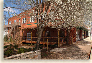 Large historic homes dot the downtown district reminding us of a time when the railroad and local natural resources brought prosperity to this out of the way mountain rail town.
You can access Main Street off of US 19/129 using Business Route 19 on either end of town. Business Route 19 becomes Andrews' Main Street, which will take you into the heart of the historic downtown 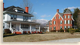 district. Shops and eateries are located in the downtown district; B&B's, cabin rentals and other lodging are available within the town and outlining areas.
Several structures in Andrews are listed on the National Register of Historic Places. The First Baptist Church constructed in 1900 and is currently known as the Valley Town Cultural Art Center was designed in the Classical Revival style. There's the Queen Anne style Franklin Pierce Cover House constructed in 1900. The Walker's Inn, built in 1825 and the ancient Andrews Mound, built in prehistoric Native American style is also on the list (mound is not opened to the public). Several other buildings in the downtown district are on the Cherokee County list of Historical Places.
The Western Carolina Regional Airport lies in the most perfectly flat valleys in the Blue Ridge Smoky Mountains. It's almost surreal to see it stretched out against a beautiful mountain backdrop. Some contribute its levelness to being shaped by the last ice age; I believe the valley in itself is unique no matter what the explanation. Along the south side of the runway there are a set of railroad tracks running straight as an arrow west, parallel to the airfield. South of the rail line in the center of the valley, the broad 4 lane super highway travels through this natural mountain corridor like destiny deemed it, what a statement in time, history and transportation.
Before leaving the Valley River Country, there's more history that needs to be shared. Up until 1838 this was all Cherokee land from the rising to the setting sun. The county was established in 1839, the same year Fort Delaney was constructed in the Valley River region for the removal of the Cherokee people in accordance to the Treaty of the New Echota.
The difficult mountainous terrain of the Snowbird Mountains between Fort Delaney in the Valley River region, and Fort Montgomery located in what is today's town of Robbinsville in neighboring Graham County was 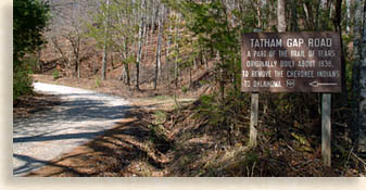 nearly impossible. A road had to be cut through the treacherous wilderness backcountry of the Snowbird's steep mountains and it was done without any instruments, in a terrain where you often can't see the sun or stars for the trees, but the trees are the key, moss grows on the north side of trees, giving something to go by. General Winfield Scott gave the orders and the US Army's troopers carried out the feat, the road is considered the first government built road in the region. The soldiers using axes, picks and saws cut this road by hand and horse team, the road is known as Tatham Gap Road, a now popular primitive forestry road that's off the beaten path. The unpaved road winds up and down along a path with curves that often seem to small to transport anything but pack mules, and to think they used wagons. You can find Tatham Gap Road across the main highway US 19/129 north of Andrews. A local county map of Cherokee and Graham Counties would be helpful on your journey.
The Valley River region is just as it appears, laid back and serene in a remarkable setting of Cherokee County's Blue Ridge Smoky Mountains.
And the Sidewalks were Paved in Marble
Along US 19/129 about half way between Andrews and Murphy in the central Valley River region is a small rural town named Marble. You wouldn't even consider there ever was a mountain valley town there. At its height of prosperity the town of Marble made a decree that their sidewalks were to be paved in marble! Not just any marble, but the finest marble in all the country. Folks came from across the county to witness such excess. Big city newspapers and magazines sent reporters to tell their readers.
 After the Trail of Tears came to a close settlers began moving into this region. It wasn't long before local minerals were being mined, tree stands being logged and a "high quality of white, gray, pink and blue marble was discovered and prepared to be quarried. The marble was discovered along the southern edge of the Snowbird Mountain range along the lower slope of a high mountaintop called "Hanging Dog."
The town of Marble found its roots when it began shipping the high grade of stone along the new rail line that dissects the county from east to west.
The high quality "blue marble" was the choice for several structures along historic downtown Murphy's Peachtree Street with the county courthouse being the most prominent. The color of the marble reflects the "blue toned hue" that is seen covering the Blue Ridge Mountains from a distance.
People moved into the area to mine, log and quarry. Several small manufacturers set up business using the local pool of labor to manufacture their goods. Today, the sidewalks have figuratively been rolled up and what was once part of a prosperous historical community has all the earmarks of a frontier western "ghost town." I've been told there is a small section of sidewalk still paved in marble in the old district, and if you knew where to look you could find it, however I haven't found it yet. Sad thing is there's not even a plaque to commemorate the event.
The marble quarry can't be seen from the main roads in town, and some of the local manufacturers have closed. Though Marble's commerce has depleted since its boom and marble sidewalk days, yet what was been left behind are the resilient mountain folks who gave up their jobs but not their homes, and lifestyle. The newly built Marble Springs Baptist Church is the centerpiece of the town now as well as the friendly country post office. Older modest homes lay along the old rail line in what was once downtown Marble while other mid 20th century brick and frame homes sit solo along open grassy knolls. Newer log cabins hang on the mountain slopes while other new constructions are tucked out of sight. I like the town of Marble, what's left, its quiet unimposing atmosphere it is very peaceful and it's past another tale in history.
Hiwassee Lake and the Unicoi Mountains
To some it's a hidden treasure; to others it's a mystery. In the northern section of Cherokee County there's a place that most county residents aren't much aware of, a place where some visitors have never heard of, and to those living there full time or those escaping away to it's a secret location, it's a secret they'd rather keep amongst themselves.
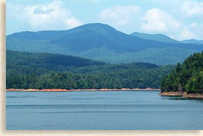
To the mountain community residents of Cherokee County in the first half of the 20th century, it was a well-needed construction project, created by the Federal Recovery Program during the Great Depression. The Tennessee Valley Authority managed and developed the project. When completed in 1940, as a flood control and electric power dam, Hiwassee Lake would cover 6,090-acres, 22-miles in length, 180-miles of shoreline and as much as 200-ft deep in places. The waters of Hiwassee Lake are fed by the Hiwassee River, Valley River and Nottely River.
The lake is a long channel lake that's much broader in some areas than others. As a recreation lake the Hiwassee Lake is all about catching striped bass, yellow perch, bluegill, and muskie to boot. It's also about pontoon cruising, boating, canoing and kayaking on the quiet blue lake's gentle surface, or maybe just skipping a river stone counting the jumps. That's just about what an average day is like during the high water season.
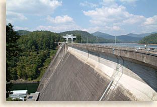 The dam area on Hiwassee Lake near the northern end of the lake offers an impressive view of some of the lake's shoreline and surrounding mountains. The dam is 307-feet, a mammoth structure and is considered the highest overspill dam in the world.
One of the reasons for Hiwassee Lake's secrecy is its geographical location just northwest of the town of Murphy. The lake area is in a more wilderness land than most mountain lakes though it is populated and most of the roads are paved. Steep foothills clog this lake region where Hiwassee River flows in the northwestern parts of Cherokee County. Past the dam the Hiwassee Lake becomes a river again for a short distance then feeds into the much smaller Appalachia Lake before continuing on as the Hiwassee River in the Tennessee Valley. The Appalachia Dam is a stroll to the North Carolina, Tennessee border.
 From the northeast to the northwest an enormous mountain range rises from the lake's surface to the highest mountains in the region. The Unicoi Mountains reach a height of 5,390-feet at Santeetlah along the Unicoi Crest. The mountains you see from the lake's surface are mere babes compared to the ones rising above your viewing point.
This mountainous region is the very back door to the Blue Ridge Smoky Mountains, a trade route that was even ancient to the Cherokee people's ancestors. The Unicoi Turnpike it was called by the white eyes, which first discovered it as a secret route. To the Cherokee it was the Trade Path, a trail that stretched across the width of the southern Blue Ridge Smoky Mountains from South Carolina to the Tennessee Valley, following it most of the way along the Hiwassee River from its headwaters in northwestern Georgia. A low gap along the western mountain range of the Unicoi Mountains on the western edge of Cherokee County was called the Unicoi Gap, a key link in the Trade Path or Northwest Passage trade route as it was also known. It was also well known as a direct route for Cherokee War Parties.
Today, Cherokee County's Joe Brown Highway  follows the old Unicoi Turnpike along the northwestern shoreline of Hiwassee Lake. Names like Hanging Dog Mountains and Boiling Springs don't nearly match the rugged terrain of these steep mountains and foothills. There's a beautiful, almost remote mountain valley community called Unaka near the end of the "paved" Joe Brown Highway/Unicoi Turnpike. The valley has seen travelers since prehistoric time. Unaka is the ancient Cherokee name that unifies nearly the entire eastern mountain ranges along the eastern Tennessee Valley.
Up ahead and beyond the picturesque community of Unaka Valley, just north of Hiwassee Lake Dam, is where Joe Brown Highway loses its pavement and becomes more like the old Unicoi Turnpike. If you don't mind some dust or some bumps in the road and if you're personally looking for a place to say to yourself, "where in the heck am I?" the Unicoi Turnpike could be calling your name.
 The forestry road along the turnpike seems to twist and turn without end. Though the mountains to the north are large and impassable, the foothills to the south and west where the turnpike travels are low and steep making for a difficult terrain to maneuver through. It's as though the ancient mountains washed out here and left all this debris you have to climb over, not necessarily the forest road itself, I'm referring to it geographically and metaphorically difficulty, impossible without the roadway or well worn trail. To be more accurate, it's only a forestry road in the 21st century, not a narrow trading path of the 18th century.
You barely notice the gap when you cross over it from North Carolina and into Eastern Tennessee. A marker along side the road on the west side of the gap tells the history of the Unicoi Gap and Turnpike. This piece of the turnpike has actual historic trail sections, untouched since its discovery. Here the trail zigzags back and forth across the old forestry road. This ancient path shows what the trail really looked like and is being preserved and maintained on the Tennessee side of the Unicoi Gap.
You can hike these same short sections of the narrow path that took a company of roughly 200 British troops and others met their fate after being forced to leave Fort Loudoun in the 1757's. These rugged and preserved trail paths are in their natural state along this mountainous trade route, having seen a lot of fur trappers, explorers, frontiersmen, settlers shoes and boots along with centuries of Cherokee moccasins on either peace missions, trading expeditions, and sometimes on the warpath.
The ancient trade route eventually became the road that took the Cherokee people from their homelands, an era had ended, and a new one began.
The British troops are gone from the Unicoi Mountains now as the newly formed American settlers moved in to stay, so did some of the Cherokees who avoided roundup during the tragic Trail of Tears.
Just to the north of the county seat of Murphy, there are still lands within the Hanging Dog Mountain region that are owned by the Eastern Band of the Cherokee along with a section of land on the east side of Murphy. Cherokee County likely has the second largest population of eastern tribal members outside of the Cherokee Boundary in northeastern Swain County, North Carolina. It's their home and always has been, and is not a public attraction like parts of the Qualla Boundary in the town of Cherokee in Swain County.
The history of Cherokee County is still recording the lives of those Cherokee whose ancestors didn't take the long journey, rather stayed and took their chances here in their ancestral homelands, instead of risking their lives and happiness by going west, where the Western Band of Cherokee reside today.
The Western Foothills and Mountains of Cherokee County
 In the western regions of Cherokee County you'll find a very quiet, tranquil part of the county. Traveling west along US 19/129 you pass through the town community of Ranger. It's the crossroad junction where US 19/129 and 74 meet that has made this community popular. Real estate offices, shops, small strip malls, gas stations, restaurants, and a flea market that's open on weekends, creates a kind of hub that lets locals and visitors know where to find Ranger.
Past Ranger traveling west along US 64/74, the mountains to the north begin their journey to the clouds as they climb to the summit of the Unicoi Mountains cresting in at 5,390-feet. Due to the tree tops and low ridges the Unicoi Mountains can't be seen for most of the journey except at a couple of valleys where they open up suddenly and then disappear again. From the highway to the south the mountain ridges begin to drop away replaced by rolling foothills and small mountains lining the upper northeast corner of a valley that extends from the town of Murphy, North Carolina to the town of Blue Ridge in North Georgia, some 35 or more miles to the southeast.
US 64/74 is the main artery in this region for access to the Blue Ridge Mountain interior or the eastern Tennessee Valley to the west. To the north and south of the highway are modest residences, and some new upscale communities intermingled with the older homesteads of mountain folk whose families have lived here for generations. Some properties are still in the hands of the families who got them in the great land lottery during the period of the Trial of Tears.
 As the highway reaches the western end of the county it passes through a small group of picturesque mountains called the Pack Mountains before crossing North Carolina and into Tennessee. From the highway on the western slope of Pack Mountain you can see across the Tennessee Copper Basin to the Cohutta Mountains Wilderness towards the west, the highway disappears into the mountains as it makes its way along the wild Ocoee River Gorge and into the Tennessee Valley below.
Here in western Cherokee County, small rural communities like Letitia, Friendship, Postell, Oak Park, Vests, Liberty, Wehutty, Sunny Point, Hot House, Wolf Creek, Johnsville and Hiwassee Dam identify the folks and families who live here in this out of the way region of the county. Its here in the outskirts of the county where you can hear a pin drop that makes it so unique. From high places you can look across the rolling foothills in all directions to the majestic high mountain ranges along the horizons.
The Highlander would like to recommend you take time to visit this area along route 294 just west of the town of Ranger on the north side of US 19/74. This route will take you back in time as you cruise the roadway past quaint farms and meadows, taking in the smell of fresh cut hay, seeing wildflowers along the roadside or spotting a few deer in the field as you wind through this serene foothill and rolling mountain country. Old historic homes as well as new homes and well planned developments dot the landscape as it gently sways up and down.
 Folks that wanted to stay away from the stress of government and town business settled this area. They felt they were governed by the only true law, the law under the church steeple, in front of the pastor's podium, the moral and ethical law of the Great Book.
There is something very special awaiting travelers along this route, it may be "awe inspiring" to some or just "awe" to others, yet impressive just the same.
Tucked away in a near hidden mountain cove is the Field of the Woods Bible Park. The first time I passed the entrance to the bible park that's cut through the narrow gap in the trees by the road, I had to do a double take while maintaining control of the vehicle of course. I just had to see this.
Just past the entrance, the bible park opens up into a perfect cove with steep slopes on three sides and a level surface below called "The Open Court." Along the surface of the right slope facing the cove is a ten-story tall exhibit of the Ten Commandments outlined in white tablet form.
The Field of the Woods Bible Park; is owned by the Church of God of Prophecy whose headquarters are located in the town of Cleveland Tennessee in the Tennessee Valley. This wooded mountain cove was a place of inspiration for one of the early church leaders who in 1903 felt guidance, illuminations and upheaval in the spirit at onset of founding the Church of God of Prophecy. Outside the park the local community is filled with historical events that took place here at the turn of he 20th century, congregation members here were united in a wilderness land while holding on to their God and faith.
Cherokee County...Land of Many Uses
From the mountains that rise in all directions, to the rivers that cross its serene valleys. From its historic mountain towns, to the ancient village sites along its waterways, Cherokee County in far Western North Carolina is one of the most unique mountain destinations in Blue Ridge Smoky Mountains.
Whether you're looking for that great, exciting outdoors experience, or just looking to draw your fly line across a rushing creek, maybe cruise the gentle waters of a mountain lake, or shoot a round of golf just to pass the time away, come to Cherokee County.
If you just want to escape to the high country to kick back and relax, or go on a personal history tour, maybe visit a renowned folk school and experience a peaceful creative environment, you'll find what you are looking for in Cherokee County.
Possibly it's your fancy to explore the local historic towns searching for those hidden treasures in the unique shops and galleries, or try out the local eateries and fine dining restaurants, whatever your choice you'll find all you want when you visit Cherokee County.
Festivals and events might be what lights your fire, or eclectic music venues, the Entertainment in Cherokee County is excellent.
Are you looking for a log cabin mountain getaway to relax on the front porch, or soak in an outdoor hot tub in the fresh mountain air? Or maybe, just maybe your cup of tea is to stay at a unique B&B, a cozy Inn or a new hotel with a pool for the whole family, Cherokee County has the lodging you desire to fit your comfort and needs.
Beautiful mountains, lakes and rivers, rich history, interesting architecture, unique shopping, friendly people, ongoing entertainment, multiple events and festivals and a nice variance of creative dining options....Cherokee County has it all....come visit us on your next trip through the mountains.
the Highlander
Use the links below to find more in Cherokee County...Murphy, Andrews, Marble, Brasstown and Peachtree North Carolina.
click map |
Murphy North Carolina - Weather.com
click banners and icons to check out our sponsor's web pages...
Murphy • Andrews • Marble • Peachtree • Ranger • Cherokee County • Western North Carolina


Your e-mail addresses will not be sold or given away to anyone.
Let our visitors tell you about the Highlander...
Click the feathers to go to the Highlander site
map...

Highlander Special Interests
Great Mountain Attractions and Destinations
Magazine, Virtual Tours and Scenic Road Trips Creative Mountain Classes Just for Kids
Living Green and Eco Friendly in the Mountains Gardening in the Mountains Mountain Recipes
Mountain and Native American History Nathanael O. Smith - Storyteller Mysteries, Myths and Legends in the Mountains
Mountain Cathedral Charities and Fundraisers
Great Mountain Retreats
Adventure • Art • Cooking • Corporate • Family • Friend • Yoga • Wellness • Youth
Learn More About the Towns and Cities in the Mountains
North Georgia Mountains Western North Carolina Mountains
Up Country South Carolina Tennessee River Valley and Mountains
Great Smoky Mountains Blue Ridge Parkway
Move to or Invest in the Mountains
Real Estate • Log Homes • Cabins • Homes • Land • Acreage • Commercial Real Estate
North Georgia Mountain Real Estate Western North Carolina Real Estate
Tennessee River Valley and Smoky Mountain Real Estate
Traveling • Living • Enjoying the Mountains
Log Cabin Rentals • Campgrounds • Vacation Rentals
North Georgia Mountain Lodging • Western North Carolina Lodging • Tennessee River Valley Lodging
Farmer's Markets • Events and Festivals in the Mountains
Restaurants, Dining and Catering in the Mountains
Shopping in the Mountains Blue Ridge Highlander Mountain Emporium and Art Gallery
Artists, Art Galleries and Art Associations in the Mountains Museums, History and Culture in the Mountains
Family Fun in the Mountains Just for Kids
Adventure and Outdoor Fun in the Mountains
Mountain Adventure Horseback Riding, Stables and Trails Mountain Bike Trails
White Water Rafting and Adventure Zipline • Canopy Tours Fishing in the Mountains
Boating and Marinas Camping and RV Parks ORV Adventures
Scenic Mountain Drives Mountain Golf Courses Mountain Day Use and Picnic Areas
National Parks in the Mountains National Forest Service in the Mountains State Parks in the Mountains
Waterfalls in the Mountains Lakes in the Mountains Rivers, Creeks and Trout Streams in the Mountains
Nature and Wildlife in the Mountains Mountain Birding Hiking Trails in the Mountains
More Information
Home Site Map Advertise on the Highlander Link to the Highlander Contact the Publisher
Legal Privacy Policy Copyright Policy

The Blue Ridge Highlander logo, all photography, design, graphics, artwork, writing, digital images, etc are the Copyright © of C. Wayne Dukes and Sherry Bell Dukes, 1996 to current day, except where otherwise stated. All rights reserved, reproduction, downloading, and/or duplication of any sort is strictly prohibited, all violations will be prosecuted. Legal Policy. If you have any questions, or comments, regarding this site, e-mail the Highlander.