| Home | Sign up for Highlander Newsletter | Order Free Brochures and & More Info | Purchase Unique Gifts, Books, Photos & Artwork |
Athens • Calhoun • Delano • Etowah • Englewood
McMinn County • Tennessee Overhill • Tennessee River Valley
Travel • Real Estate • Adventure • Fly Fishing • Tennessee Overhill
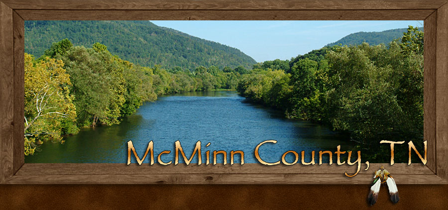
McMinn County in southeastern Tennessee is the heartland of the Overhill Country, more commonly known today as the Tennessee Overhill. McMinn County is located between Monroe County to the north and Polk County to the south. A treaty with the Cherokee People on February 27, 1819, lead to the founding of McMinn County on November 13, 1819.
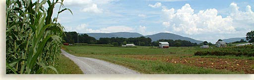
McMinn County lies in the Tennessee River Valley along the edge of the Starr Mountain Range of the Cherokee National Forest. This land of the great valley lined with mountains is also crisscrossed with waterways created by the watershed of the southwestern Blue Ridge Mountains, a land known for great fishing and outdoor adventures. The Hiwassee River borders the southern end of the county and the Tellico River is just over the northern border of the county. Easily accessible creeks and streams within the county flow through and divide many of the family owned farms.
McMinn County is an ideal destination when visiting the Tennessee Overhill country. The unofficial motto for the county should be, “you can get there from here.” From its central location, you can head south into the wild river country of the Ocoee River where time and history have cut a path thru the Cohutta Mountain Wilderness, the third largest wilderness in the eastern United States. To the north of the county, the path of the Tellico River will lead you from the valley floor to the clouds above.
McMinn County Tennessee Communities
 McMinn County is a perfect example of down home southern style living. The beautiful countryside of McMinn County is dotted with small farms and quaint towns. Mountain towns like Etowah, Englewood, Calhoun and Delano are set against a backdrop of blue-mountains towering against the eastern sky.
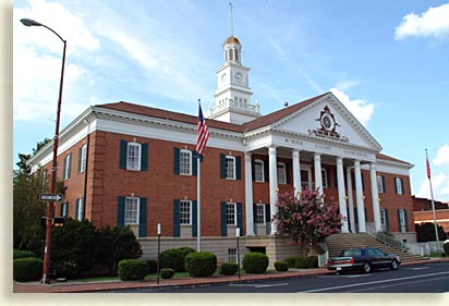
The mere size of the county courthouse, located on the far western side of the county in the town of Athens along the Interstate 75 corridor, displays the strength and prosperity of Tennessee Valley’s McMinn County.
At the base of the Star Mountain Range in southeastern end of the county is the town of Etowah; the town clearly demonstrates the coming of an age at the turn of the 20th Century. Etowah became the backbone hub of the growing textile industry and the local mountain logging industry in McMinn County. Though the railroad originally came to Calhoun in McMinn County as early as 1837, it wasn’t until the turn of the century that the town of Etowah was founded, it was to be the central-rail location for the southeastern Tennessee River Valley.
In 1902 Etowah was nothing more than farmland until the Louisville and Nashville Railroad purchased the land with the  intention of building a railroad town there. Making Etowah the new Atlanta Division Headquarters. To show how serious the entrepreneurs at the Louisville and Nashville Railroad were, they selected to build a grand depot on the edge of a wilderness in the Tennessee River Valley and christened it the centerpiece for the town Etowah.
A New Century and a New Boomtown were on its way, bringing culture and prosperity to the outskirts of McMinn County. By the 1920’s Etowah’s population had reached its peak with over two thousand railroad employees. Up to 20 trains passed through Etowah on a daily basis transporting passengers and moving large quantities of textile goods from local manufacturers plus raw lumber harvested from local mountains. These material goods were aimed at quenching the thirst of a young and growing nation.
Today much of the town looks like it did at the turn of the century; a broad main street divides the merchant district from the railroad company. The grand Etowah Depot stands directly across the street from the Gem Theater built in 1927. Today the Theater is owned by the City of Etowah, presenting live stage performances weekly. Parts of the downtown are is under renovation with tremendous potential for unique shops, dining and lodging. Etowah offers a variety of southern hospitality or rather Tennessee charm.
Etowah, what's in the name?
The name Etowah is believed to have several origins, some believe it took hold when railroad workers drug a sign here with the name Etowah painted on it. The Blue Ridge Highlander prefers to believe that the name Etowah likely derives from the ancient Mound Builders, a Mississippian Culture located in lower regions of the great valley, ridges and rivers.
 Rivers like railroads were a necessity for transporting trade goods. The Etowah People built a fortified mound city at the southern most tip of the Tennessee River Valley; in Georgia, the Georgian’s refer to the river valley as the Great Valley and Ridges.
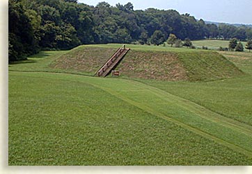
There on the banks of the Etowah River just outside present day Cartersville, Georgia, the Etowahian People built their fortified city with inhabitant numbers into the thousands. An agriculture and trade society built the mound city as a center for political and religious activities.
Three mounds were built for ceremonial purpose. The largest of the three mounds is several stories tall. The Chieftain Mound had a temple crowning its summit where the chief-priest lived. A clay surface plaza spread out below the mound serving as a market place and was used for ceremonial purpose. The Etowah Mounds Historic Site is open to the public, offering a unique opportunity to experience early American history.
Up the road from Etowah on highway 411 you’ll find Englewood, another railroad town built by the L and N Railroad. The town of Englewood was originally called Tellico Junction. Englewood was figuratively built by the railroad to serve as a textile town. You’ll still find that turn of the century charm it has had for over 100 years.
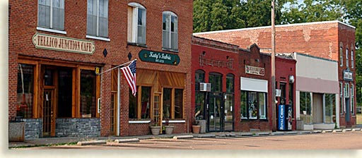
The Overhill area of the Tennessee Valley has a long history in the textile industry, money in the local farm communities were scarce in the late 1800’s. Cheap wages were offered were offered by these textile companies, better low wages than no wages at all, brought young people off the farms and into the manufacturing businesses. Here in the Tennessee Valley you’ll find their story in the Englewood Textile Museum. The museum tells the tale of life in a textile town in the rural south during the early 20th Century.
Though it’s the great mountains and rivers of the Overhill country that often capture most of the attention, it’s the rural farm communities and agriculture world that are the personal pride of the local folks of McMinn County.
In the local valley town of Delano, you will find a working Amish community. This place is truly a throw back in time, simple farms, simple ways and horse drawn buggies make this community a must see, come enjoy, taste their wares and experience their lifestyle, there is a lot to say for simplicity.
Several museums throughout the county tell the history of McMinn County. At the Depot in Etowah you’ll find the history of the Railroad Museum. The Tennessee Overhill Heritage Association also makes its headquarters there within the Depot along with the Etowah Area Chamber of Commerce.
Two other interesting museums in the county are the McMinn County Living Heritage Museum displaying exhibits of small town life and crafts including one of the South’s largest quilt shows. The Swift Museum, located at the McMinn County Airport draws aviators and air show fans. There you’ll find authentic restored versions of the original Globe and Temco Swift airplanes. Once a year on Memorial Day Weekend the Swift aircraft and pilots converge here for the Swift National Fly-In Air Show.
As the Blue Ridge Highlander stated, it’s the mountains and rivers of the Tennessee Overhill that brings most of the attention to McMinn County, there’s plenty of outdoor adventure waiting for you in McMinn County and the Tennessee River Valley.
Cherohala Skyway
After a short side trip up the Tellico River Gorge return back to highway 165 and continue eastward and upward into a doorway to the sky. The Cherohala Skyway is a spectacular scenic byway that travels over 50 miles across the Unicoi Mountains reaching heights of 5,390 with numerous scenic overlooks and hiking trails along the route. Views to the north from the Cherohala Skyway will show you the Great Smoky Mountains. To the west you’ll see the deep Tennessee River Valley.
The need for a route over the Unicoi Mountains connecting Tellico Plains, Tennessee to the remote mountain town of Robbinsville, North Carolina was motivation for the opening of the Cherohala Skyway, which was accomplished in 1996 taking 30 years to complete. The skyway follows the path of and old wagon train route that was formally an ancient Native American trail.
At the end of the Cherohala Skyway in North Carolina is the Joyce Kilmer Memorial Forest, named after the author of the poem, “Trees.” This is one of the rare old growth-forest in the Blue Ridge Mountains that escaped the logging saws of the late 18th early 19th Centuries.
Some of the trees along the moderate hiking trail are 20 feet round, over 150 feet high and as much as 400 years old. After leaving Joyce Kilmer Memorial Forest you’ll find the trip back across Cherohala Skyway is just as spectacular.
Copper Basin Ocoee River
At the headwaters of the Ocoee River in the interior of the mountains to the southeast of McMinn County is the historic mining town of Copperhill, Tennessee. Discovered in the late 1830’s during a 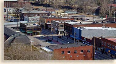 search for gold, copper ore was found in abundance. In what would become known as the Copper Basin, local history tells the tale of the largest copper mining industry in North America, a land that was severely abused for the sake of company profit.
Roughly 60,000 acres were destroyed due to acid rain from smelting copper ore. The local lands and mountain were stripped of timber, used as fuel to smelt the ore. Greed and lack of concerns for the environment rendered the landscape barren of any natural growth. Profiteers lack the knowledge of the permanent damage they were doing and local mountain folk were hard pressed for cash and the opportunity to support their families during these hard economic times.
Locals considered the scarred land to resemble a moonscape, early astronauts could see a man made desert within an eastern mountain range as they gazed out of their capsules from space. Today with great effort and concern, the land has been replanted with trees returning beauty to this region of the land as it was before the days of logging. The Ducktown Basin Museum in Polk County depicts the history of this mining region. A few of the landscape scars were left as a reminder of the damage done to this region.
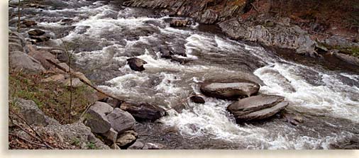
Flowing down from the Copper Basin area is the wild Ocoee River. Following the only natural path out of the mountains thru the southern Cherokee National Forest is the Ocoee River, whose rushing white waters carved out a deep gorge on its way to the valley below.
The Ocoee River Gorge and its challenging white water was 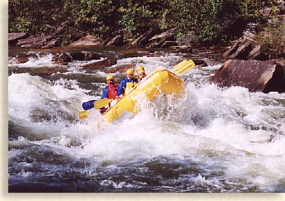 the site for the 1996 Olympic Whitewater Slalom and Kayak Races. The Ocoee River is one of the most premier white water rafting rivers in the country and enjoyed by tens of thousands of rafters and kayakers a year. Whether you ride the wild waters of the river or just enjoy being a spectator of white water rafting and kayaking, you can easily enjoy the view of this recreation at one of the several pull offs along the road or at the Ocoee Whitewater Center when the Upper Ocoee River is surging with wild waters.
Following along the north bank of the Ocoee River Gorge is the Ocoee Scenic Byway on U.S. 64. This was the first scenic byway ever established in the United States. This scenic and awe inspiring route winds thru the gorge below high rock walls and forest, following parts of the Old Copper Road which was first built in 1843.
Today a newly opened system of mountain biking and hiking trails begin at The Ocoee Whitewater Center. The trails zigzag and loop for miles through the backcountry of the Cherokee National Forest and Cohutta Wilderness.
Clinging to the wall on the southern side of the gorge is a century old wooden water box that carries water from the century old wooden dam and lock to the lower powerhouse where the rapids end.
When the Ocoee River exits the gorge it flows into 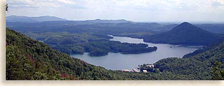 the gentle waters of Ocoee Lake, the Byway continues along the north shore of the lake until it reaches the main dam where the river leaves the mountain country of the Cherokee National Forest. Mid way along the lake you’ll find the ranger station. Exiting here will take you up a paved road to the tops of Chilhowee Mountain. There are several overlooks along the route offering spectacular views of Ocoee Lake below with vistas of the Cohutta Mountain Wilderness to the east and the great Tennessee River Valley to the west bordered by the Cumberland Mountains on the far distant western horizon.
Ocoee Lake is a popular recreational lake in the foothills of the southwestern Blue Ridge Mountains and great for boating. The Ocoee River is a must see and do experience when you visit the Tennessee Overhill Country.
Tellico River and Upper River Gorge
Just over the northeastern border of McMinn County is the Tellico River. This wide and moderate flowing mountain river is used less for rafting and more for its unique purpose, fly fishing and canoeing. Highway 165 follows the riverbank several miles before the river narrows into the Tellico River Gorge.
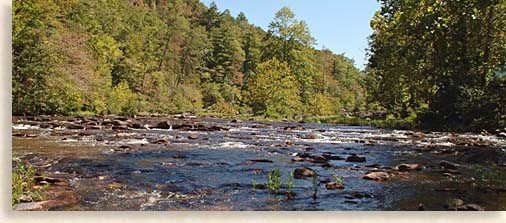
You can continue to follow the paved forestry road to the right along the narrow cascading Tellico River. The river flows along the right side of the road, the steep rock walls along the outer riverbank are beautiful.
Following the Tellico River a short distance brings you to Bald River Falls. This outstanding waterfall can be viewed easily from the road’s bridge; a path to the left of the falls leads up to the top of the falls, rocks close to falls are often slippery and can be dangerous, be sure to exercise caution, and heed posted warnings. Continuing further up the road from Bald River Falls, you’ll pass more cascades and another waterfall along the river about half the size of Bald River Falls and beautiful in their own right. For you fishing buffs, beyond the falls is a fish hatchery and the Upper Tellico River Gorge is narrow in some places yet great for fly-fishing.
Hiwassee River
If that’s not exciting enough for you, McMinn County offers the thrill of repelling off the cliffs and high bluffs along the northern banks of the Hiwassee River located on the southeastern tip of McMinn County just south of Etowah.
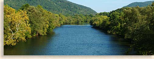
For a little more sensible thrill you can take route 30 and travel east along the southern banks of the Hiwassee River and enjoy the scenic view of a wide and more tamed river as it flows between high mountain ridges. Here you can take in the beauty of river bottomland, farmsteads and a town lost in time, the mostly undeveloped community of Reliance.
This laid-back mountain country style atmosphere offers a sense of leisure and comfort to sightseers and hikers alike. There is though one particular type of sports person who venture here year after year, and just can’t get enough of a good 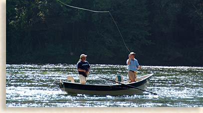 thing, that is the dedicated fly fisher. The beauty, the tranquility and easy access along the northern bank of the river make the Hiwassee River the river of choice for fly-fishing. You can just leave your cares and worries behind and let your troubles drift away along on the river’s current while casting line and lure again and again, standing waders deep in the gentle current of the Hiwassee River. Rafting, canoeing and tubing are also enjoyable recreation along the crystal blue waters of the Hiwassee River.
John Muir the famous America naturalist who was instrumental in putting the renowned Yosemite Valley, America’s first National Park on the map found his way into this river region in the late 1800’s. So intrigued, so awe inspired was John Muir by the beauty and serenity of the Hiwassee River that an 18.9-mile trail was established along its banks and honored by his name. Here in the backcountry and winding its way thru the foothill of these western Blue Ridge Mountains is the John Muir National Recreation Trail. You can walk in his footsteps knowing that the wonders he once experience here are preserved for all generations to come.
McMinn County, the heart of the Tennessee Overhill country has the experience and all the amenities your looking for. If you desire the excitement of rugged mountains, swift rivers and the great outdoors along with the leisurely comfort of home in a rural southern setting, McMinn County has all that and more, join us and be apart of that good down home feeling.
Cherokee National Forest in McMinn County
Calhoun • Delano • Etowah • Englewood
McMinn County • Tennessee Overhill • Tennessee River Valley
Sign up for the Blue Ridge Highlander Newsletter, Messages from the Mountains
to find out first about our new feature stories, road trips and special offers
Your e-mail addresses will not be sold or given away to anyone.
Privacy Policy
Interested in your business being on the Highlander, click here...
Let our visitors tell you about the Highlander...
Click the feathers to go to the Highlander site
map...

Your e-mail addresses will not be sold or given away to anyone.
Let our visitors tell you about the Highlander...
Click the feathers to go to the Highlander site
map...
Highlander Special Interests
Great Mountain Attractions and Destinations Links to All Highlander Advertisers
Blue Ridge Highlander Mountain Emporium Art Gallery Photo Gallery Handmade Products Book Store
Magazine, Virtual Tours and Scenic Road Trips Creative Mountain Classes Just for Kids
Living Green and Eco Friendly in the Mountains Gardening in the Mountains Mountain Recipes
Mountain and Native American History Nathanael O. Smith - Storyteller Mysteries, Myths and Legends in the Mountains
Mountain Cathedral Charities and Fundraisers
Great Mountain Retreats
Adventure • Art • Cooking • Corporate • Family • Friend • Yoga • Wellness • Youth
Learn More About the Towns and Cities in the Mountains
North Georgia Mountains Western North Carolina Mountains
Up Country South Carolina Tennessee River Valley and Mountains
Great Smoky Mountains Blue Ridge Parkway
Move to or Invest in the Mountains
Real Estate • Log Homes • Cabins • Homes • Land • Acreage • Commercial Real Estate
North Georgia Mountain Real Estate Western North Carolina Real Estate
Tennessee River Valley and Smoky Mountain Real Estate
Interior Design and Furniture Shops Schools in the Mountains
Traveling • Living • Enjoying the Mountains
Log Cabin Rentals • Vacation Rentals • Resorts • Condos • Inns • Hotels • Bed and Breakfasts
Luxury Resorts and Spas in the Blue Ridge and Smoky Mountains
North Georgia Mountain Lodging Western North Carolina Lodging Tennessee River Valley Lodging
Plan a Mountain Wedding or Gatherings Conference, Meeting and Retreat Facilities
Vineyards • Wineries • Tasting Rooms Agri-Tourism Farmer's Markets
Yoga Retreats • Spas in the Mountains
Events and Festivals in the Mountains Theatre • Concerts • Mountain Entertainment
Restaurants, Dining and Catering in the Mountains
Shopping in the Mountains Blue Ridge Highlander Mountain Emporium and Art Gallery
Artists, Art Galleries and Art Associations in the Mountains Museums, History and Culture in the Mountains
Family Fun in the Mountains Just for Kids
Adventure and Outdoor Fun in the Mountains
Mountain Adventure Horseback Riding, Stables and Trails Mountain Bike Trails
White Water Rafting and Adventure Zipline • Canopy Tours Fishing in the Mountains
Boating and Marinas Camping and RV Parks ORV Adventures
Scenic Mountain Drives Mountain Golf Courses Mountain Day Use and Picnic Areas
National Parks in the Mountains National Forest Service in the Mountains State Parks in the Mountains
Waterfalls in the Mountains Lakes in the Mountains Rivers, Creeks and Trout Streams in the Mountains
Nature and Wildlife in the Mountains Mountain Birding Hiking Trails in the Mountains
More Information
Home Site Map Advertise on the Highlander Link to the Highlander Contact the Publisher
designed, produced and hosted by

of C. Wayne Dukes and Sherry Bell Dukes. 1996 - 2014, except where otherwise stated. All rights reserved, reproduction,
downloading, and/or duplication of any sort is strictly prohibited, all violations will be prosecuted. Legal Policy.
If you have any questions, or comments, regarding this site, e-mail the Highlander.