Waterfalls and Trails of Southern Jackson County's Cashiers Area
Several popular and spectacular waterfalls are located in the Cashiers area and the neighboring counties to the east and west. This area is truly a legendary waterfall region; many of these waterfalls are easy to access along short trails, still others can be viewed along the main roadways, especially along US 64 west of Cashiers and the town of Highlands.
The first three waterfalls, hiking trails, and powerful set of cascading falls along Fowler Creek are south of Cashiers, accessible from Hwy 107. There are other trails in this region (not necessarily noted for waterfalls) accessible along Hwy US 64 both east and west of Cashiers and Hwy 107 in Jackson County.
Cashiers Sliding Rock, Chattooga River Trail and Whiteside Cove Road: Located on Whiteside Cove Road just south of the town of Cashiers is Sliding Rock. This site is one of those great, natural, old-fashioned swimming holes with a giant rock across the waterway that forms a beautifully rounded, smooth rock surface waterfall. This waterfall formation creates an excellent "sliding rock" custom-made for water fun and/or a great photo opportunity for active young folks or playful water lovers. If you're looking for fun water adventure, there are swimming holes located both above and below the falls. These naturally formed wonders are a great place for play, yet can be very dangerous just the same, due to slippery rocks or hidden underwater objects. Children need supervision for an enjoyable day at play, both small kids and big kids alike. There are no lifeguards available; visitors participate at their own risk.
To reach Cashiers Sliding Rock, take Hwy 107 south from the town of Cashiers for 1.9 miles and turn right onto Whiteside Cove Road. Continue on Whiteside Cove Road for 2.8 miles; after crossing the bridge, pull off onto the right shoulder of the road and park. (There is limited parking and it may be crowded during weekends and warm season vacation times.) From the parking area, follow the trail for about 100 yards to what's called by many "Little Sliding Rock."
Farther west on Whiteside Cove Road are dramatic views of the enormous cliffs along the southern face of Whiteside Mountain. Cradled alongside the roadway is the modest-size Holly Berry Mountain Lake. This lake acts as a reflecting pond, mirroring the image of Whiteside Mountain above. A bridge just pass the lake crosses the Chattooga River, after crossing the bridge there's a parking area on the south side of the road and an access to the Chattooga Trail. This upper river trail area above Bull Pen Road is known for its scenic river views and rugged terrain. It is closed to boats and can only be reached by foot. Two popular features along the trail are the Chattooga Cliffs and a small gorge called the Upper Narrows. The majority of the Chattooga Trail winds thru the Elliott Rock Wilderness and throughout the tri-state area of Western North Carolina, South Carolina, and North Georgia.
Located further west along Whiteside Cove Road there's a historic community structure. Built in 1917 the structure served as a church, schoolhouse, and community center. The first settler Barack Norton arrived in the area in the 1820's; his descendants have held their annual family reunion at this site since the 1870's.
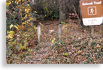
Silver Run Falls: Located along Hwy 107, some 4.3 miles from the town of Cashiers, is Silver Run Falls. There's an accommodating parking area on the left side of the roadway and a sign for Silver Run Falls, which isn't always easy to find. If you pass the waterfall's parking area and see a sign reading Nantahala National Forest, you just missed the parking area.
From the parking area, the trail leads about 50 yards to a foot bridge crossing a stream--the old method of crossing the stream was by traversing a large log spanning across the stream. In fact, the old well-worn log with carved foot notches still remains across the stream. After crossing the bridge, travel another 100 yards to the edge of the waterway and expect to be amazed at the power of the falls pouring over the ledge of the cliff and into a large body of water below.
Whitewater Falls: Whitewater Falls is the tallest and most spectacular waterfall in the Southeastern United States. This single series of mighty waterfalls roars over a mountain ledge, creating two largewaterfalls--along with several smaller falls--that drop directly into the river 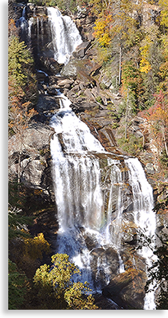 and the valley below. The falls are so large, they can actually be viewed from satellite images. The fallsare located on the Whitewater River.
The reason for the waterfall's dramatic appearance is a sharp drop in elevation from the mountains above to the piedmont below known as the Blue Ridge Escarpment. The majority of this escarpment shows little human intrusion due to the steepness of the landscape. What remains is a more primitive and pristine natural setting than other more popular points of interest throughout the Blue Ridge Smoky Mountain Province.
Whitewater Falls straddles both the North Carolina and South Carolina state lines. The Upper Whitewater Falls is on the North Carolina side of the Whitewater River and plunges 411 feet; this descent is followed by the Lower Whitewater Falls' 400-foot drop on the South Carolina side of the river.
Whitewater River Recreation Area is open year-round and offers ample parking, plus trails, picnic tables, and restrooms. A paved handicap-accessible trail leads from the parking area to the upper falls overlook; a long set of stairs leads to a lower deck overlook of the waterfalls. On sunny days, rainbows often appear in the falls as they cascade over bare rocks and down into the river below.
The main hiking trail that passes through the heart of this recreation area at Whitewater Falls is the Foothills Trail. The Foothills Trail is an 85-mile trail that traverses the Blue Ridge Escarpment of both North and South Carolina. The Foothills Trail accesses views of both the Upper and Lower Whitewater Falls.
To reach Whitewater Falls, take Hwy 107 south of Cashiers for 9.5 miles to the state line. Shortly after crossing the state line, watch for the sign to Whitewater Falls and follow the directions; it can be a little tricky to find, but don't give up, you won't want to miss this spectacular site. Whitewater Falls is located along Hwy 281 at the state line of North Carolina and South Carolina.
Gorges State Park: Located just north of Whitewater Falls along Hwy 281 is North Carolina's Gorges State Park. The new parklands and Welcome Center for Gorges State Park opened in 2013. Its plunging waterfalls, rugged river gorges, and sheer rock walls contain one of the greatest concentrations of rare and unique species in the eastern United States. Gorges State Park can also be accessed along its eastern park border, off Frozen Creek Road south of the town of Rosman.
The main western entrance off Hwy 281 leads to the Welcome Center. From the center, a looped roadway with a southern extension leads to park overlooks and access to several park trails, including Bearwallow Falls Trail and Rainbow Falls Trail. Bearwallow Falls Trail, located along the northern end of the loop, is a moderate 1-mile hike; Rainbow Falls is a strenuous 3-mile hike. Rainbow Falls Trail, along the southern end of the looped roadway, leads just outside the parklands to Horsepasture River and Gorge. Horsepasture River is a designated Wild and Scenic River. There are several other falls along this stretch of river, such as Drift Falls, Second Falls, Stairstep Falls, and Windy Falls. This river gorge area is wild and rugged; only experienced hikers should attempt exploring the area of Horsepasture River, and should never attempt it alone. Day hikers should carry plenty of water and energy snacks.
Horsepasture River Trail and Waterfalls: Located east of Cashiers off US 64 is Horsepasture River Trails and Waterfalls, a designated Wild and Scenic River. The river is not all that big; it's the waterfall that makes it so grand.
There are 5 spectacular waterfalls located along a 2.8-mile stretch of the deep river gorge. A moderate-to-strenuous trail follows along the river path, with side trails that lead to each set of waterfalls. The names of these notable falls are Drift Falls, Second Falls (also known as Turtleback Falls due to its unusual shape), Rainbow Falls, Stairstep Falls, and Windy Falls. The two most popular falls are the Drift and Turtleback Falls, located near the trail access point on Bohaynee Road. It's common for visitors to use these two falls and gathering pools for swimming and rock sliding. Rainbow Falls, the second largest in the series of waterfalls, has a 200-foot drop into a deep pool. Reaching Stairstep Falls can be confusing due to the configuration of the falls--a series of seven cascades over approximately 10-foot wide steps. Windy Falls is the most difficult to reach and observe and is only recommended for more experienced hikers. Because Windy Falls cascades 700 feet down a narrow gorge, it is considered impossible to photograph in its entirety.
 Yellow Mountain Trail: Yellow Mountain Trail is a 4.8-mile trail rated strenuous, only recommended for experienced hikers. The trail leads to a stone and wood fire tower that at 5,127 feet above sea level offers outstanding views. Yellow Mountain Trail is located on Buck Creek Road just off of US 64.
To reach Buck Creek Road, drive west on US 64 for about 7.5 miles from the town of Cashiers. Buck Creek Road will be on the right. Follow Buck Creek Road for 2.2 miles. The trailhead is on the right side of the road, marked by a sign and a set of steps leading from the trailhead.
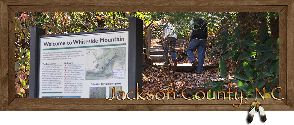
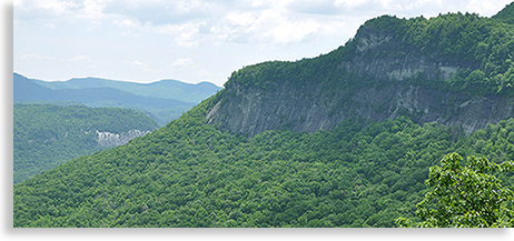 Whiteside Mountain and Trails: Whiteside Mountain, located along US 64 between the towns of Cashiers and Highlands, is a landmark mountain along the Eastern Continental Divide. This ancient megalith of a mountain is believed to be between 390 and 460 million years old and was formed by a huge mass of molten rock deep within the earth. Cooling, heating, pressure, and uplifting brought into view the mountain seen today. It is believed that Whiteside Mountain is older than the formation of plate activity that created the North American Continent. A two-mile moderate-to-difficult trail leads from the parking area to the upper 750-foot high cliff tops.
A variety of wildflowers flourish along the trail. Hikers, rock climbers, and repelling enthusiasts who enjoy Whiteside Mountain's rugged challenges are often rewarded with sightings of the Peregrine falcons that make their home here among the high cliffs.
To reach the parking area for Whiteside Mountain, take Hwy US 64W from Cashiers for about 5 miles and turn left onto Whiteside Mountain Road; follow to the parking area and trailhead.
Fowler Creek and Bad Creek Trail:Bad Creek Trail is located within the Ellicott Rock Wilderness Area and is considered a strenuous 7-mile round trip. Take Hwy 107 south of Cashiers for 7 miles to Bull Pen Road and turn right onto an unpaved forestry road. Drive 2.7 miles, cross the bridge at Fowler Creek, and look for the parking area and trailhead access. If you're not up for a 7-mile hike, the drive to Fowler Creek Bridge is still well worth the journey. A view from the bridge reveals a park-like setting alongside an enormous set of cascading waterfalls powering over giant boulders.
After Fowler Creek passes under the bridge, the creek emerges into a calmer, cascading water flow, perfect for anglers looking for some great fly-fishing adventure. Bullpen Road cuts through the northern end of the Ellicott Rock Wilderness Area with other trail access points along the roadway. A trail map for this region is highly recommended for experienced trail hikers.
Panthertown Valley Waterfalls and Trails: Located east of the town of Cashiers and north of US 64 is the pristine mountain region of Panthertown Valley, recognized as "one of the more magnificent areas in the southern Appalachian Mountains." Though open to the public, the area is considered both biologically significant and fragile, and requires respect and recognition in order to preserve this unique environment.
This protected area contains 6,700 acres accessible by hiking trails and footpaths. Most of the main trails were once logging roads when lumber was king in these mountains. These old logging roads are great for mountain biking, whereas the narrow trails and footpaths are more delicate and require proper consideration in order to keep the valley in a pristine state. There are numerous streams flowing through the valley that occasionally form beautiful waterfalls; one of the more popular waterfalls in Panthertown Valley is School House Falls.
The western entrance to Panthertown Valley is approximately 10 miles from Cashiers, yet only two miles of the distance is on US 64. Several smaller, paved side roads lead into the valley. Both the eastern and western entrance to the valley can be a little difficult to locate, yet well worth the journey.
To access the eastern entrance to the valley from Cashiers take US 64 past the town of Sapphire to Hwy 281 and turn left heading north. The highway follows along Lake Toxaway. Turn left onto Cold Mountain Road; the roadway winds up the mountain and ends near the parking area for the eastern entrance to the valley. Schoolhouse Falls, the closest falls to either valley entrance is located along this eastern entrance to the valley.
I recommend that visitors seek directions from the Cashiers Chamber and Welcome Center or the local Ranger's Office. One should consider Panthertown Valley to be a hidden gem and a wondrous area to experience. This valley is on the future Blue Ridge Highlander story list for further exploration.
Click Here to Continue Exploring Jackson County...
| Cabin and Vacation Rentals |
 |
|