| Home | Sign up for Highlander Newsletter | Order Free Brochures and & More Info | Purchase Unique Gifts, Books, Photos & Artwork |
Dawsonville • Barrettsville • Silver City • Juno • Johntown • Dawson County • North Georgia Mountains
|
 The gold strikes along the southern slopes of North Georgia’s Blue Ridge Mountains were what brought the first permanent white settlers to the region as early as 1829. One major problem was that this bounty of gold laden veins along with streams of gold nuggets was on Cherokee land.
  the most assimilated Native American tribe our young country had known at the time. The Cherokee just wanted to be left alone; many tribal leaders were prosperous businessmen and well educated. Yet, in the late 1830’s, after a long political fight in Washington, a controversial treaty was signed by several leading members of the Cherokee Nation who agreed to leave for lands west of the Mississippi River. The remaining 4,000 to 6,000 Cherokee people were forced from their homelands along an ill-fated exodus to Oklahoma called the “Trail of Tears.” The bitterness of the experience has never left the Cherokee people yet their legacy has remained throughout Dawson County in location with names like Toto Creek, Etowah and the popular attraction Amicalola Falls. Its easy to recognize these Cherokee names and often difficult to pronounce.
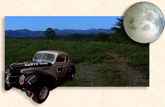
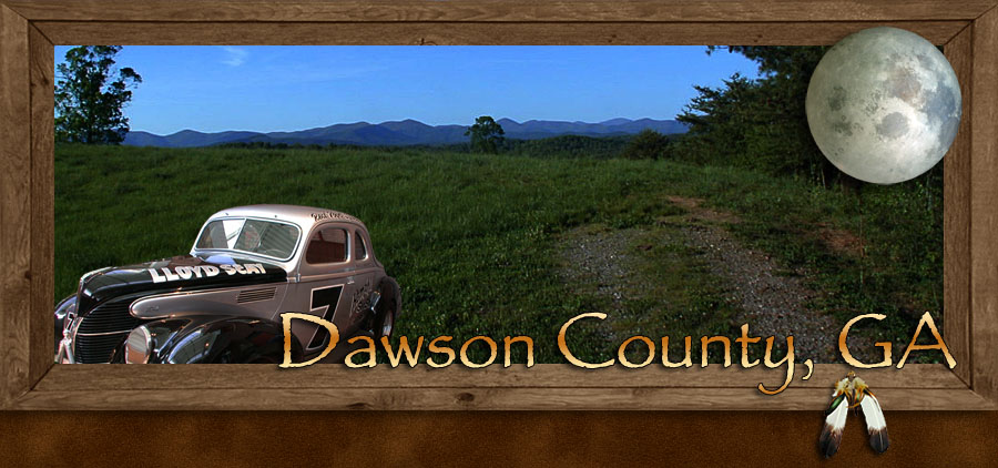
 Atlanta was always a time allotted priority with early technology leading and hindering the way. More speed and more stealth were required, in the early days as the moon trippers followed the waxing and waning of the moon. On a clear night the highways were full moon bright, and darkened shadows of trees and buildings provided convenient cover. Running a blockade (road block) in those early times, were to the advantage of the moon tripper. He knew the home field route and the particular time of departure, plus the early squad cars lacked communication radios. All moon trippers had to do was out run the cops. The more capable the law enforcement got the smarter and more daring these moon trippers had to become. Faster cars and more cunning routes were required to evade the heavy rule of the law.
Located along highway 53 in the heart of Dawson County is Dawsonville, home of the county seat. Created by a legislative Act on December 3, 1857 Dawsonville became the hub of commerce in the mid 1800’s. The county courthouse stands in the middle of highway 53. With little more than a side walk and a narrow line of grass around the courthouse the property isn’t big enough to be considered a town square. On an island in the middle of the highway the structure, stands solid and secure considering this building hasn’t budged since it was first built in 1860. Before its construction, official court duty and legal wrangling were conducted at a log courthouse with a reinforced jail.
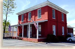 The historic Dawson County courthouse along with the historic county jail are the cornerstones of Dawson County heritage. Fire destroyed the original jailhouse soon after completion, the second jail was completed 1881, while prisoners were held in neighboring lockups until the jail was finished. Still standing today, across the street from the courthouse is the 1881 jailhouse. The courthouse and jailhouse are both listed on the National Register of Historic Places.
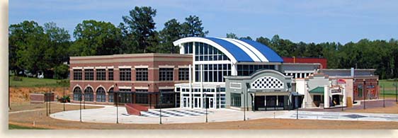
Remnants of the old gold town of Dawsonville appear throughout the town with modest, aged structures standing alongside new architecture. The new City Hall is a prime example of Dawsonville’s growth. Ruins of old mining operations can be seen throughout the county as well as within the city limits of Dawsonville.
Strolling, dining, shopping lodging and local history can fill your stay in Dawsonville.
You’ll definitely want to take in the history of outlaws of the highway when you visit some of the sights and exhibits of the old moonshine days when visiting Dawsonville. The history of NASCAR starts here, a sport built out of troubled times, daring young men, illegal liquor and you know the rest.
Dawsonville is the largest historic mountain town in Dawson County yet in size its still quaint and homespun just like the local mountain folk like it. A town lost against the Blue Ridge Mountain slopes and only an hour away from bustling Atlanta.
Local communities and newly developed neighborhoods pride themselves on the local country charm the town Dawsonville displays a comfortable hometown leisure feeling that seems contagious throughout Dawson County.
Dawson County, convenient to the mountains, the lake, shopping, dining, lodging and the city, most of all its convenient to fun, relaxation and the beauty of God’s Country. Below is a list of some of the things to do when visiting or living in Dawson County.
Wilderness Backyard
 Some visitors to Dawson County see the county as a shopping destination while others see Dawson County as a weekend getaway spot.
Many visitors have bought a seasonal home with plans of early retirement while others relocated to Dawson County, taking advantage of the manageable commute to the Atlanta metropolitan area.
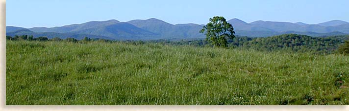
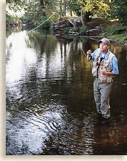
Then there are those who come for the beauty and natural wonders Dawson County has to offer. Lake Lanier is accessible in southern Dawson County, while the Blue Ridge Mountains border the northern regions of the county. Fishing, hiking, rafting, mountain biking, horseback riding, boating, skiing, swimming, scenic tours and a hopping outback fully equipped with 300 kangaroo.
All this is awaiting you in a land of great mountain vistas, dramatic waterfalls plus the comfort and leisure of home. The backwoods and mountain lands of Dawson County invite visitors to enjoy their unique corner of the Blue Ridge Mountains.
Amicalola Falls State Park
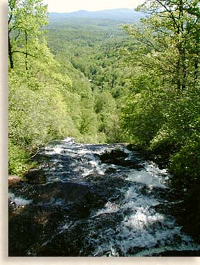 Located along highway 52 in the northern mountainous regions of Dawson County is Amicalola Falls State Park. The Cherokee word Amicalola means “tumbling waters” a worthy title considering the waterfalls 729-feet from overflow to catching pool. Amicalola Falls from a distance looks like one long continuous waterfall. Amicalola is a series of seven cascading waterfalls that give the illusion that Amicalola Falls is one long waterfall. You can view a large portion of the falls when you first enter the state park, for a fuller view of the falls you need to take highway 52, west from the state park entrance, within a mile of two you’ll reach the junction of highway 52 and 136. Turn your vehicle around and head back towards the park, from this point of driving you have the advantage of see a large portion of the waterfall especially in the late fall.
Viewing from the distance, you can see why it looks as though it is one very long straight fall.
The waters of the waterfall coming off Amicalola Mountain are particularly more dramatic after a good rainfall; this waterfall definitely lives up to its Cherokee name “tumbling waters.”
Amicalola Falls State Park is comprised of 1,440-acres of mountain woodlands along the Amicalola Creek watershed. Available within the park are lodging rooms, hike inn rooms, 24 campsites 14 cottages plus 4 picnic shelters and a 1 group shelter, all require reservation for use.
 Miles of trails lie within the state park with marked trails leading into the forest; the one main trail follows alongside the Amicalola waterfalls on a moderate to strenuous hike, the easiest and most comfortable way to reach from the bottom of the falls to the top is by taking the park road to the top of Amicalola Falls. The parking area at the top of the falls offer a viewing deck over the falls and a beautiful mountain and piedmont view of Dawson County to the south.
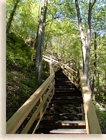
Along the right side of the top of the falls or to the west if your carrying a compass, is a very well made stair case with platform decks leading down to the bottom of the first set of falls. The trip down the stairs is well worth the journey but what goes down must come up, it’s best to know your personal physical limitations.
From the upper falls, the Approach Trail to the Appalachian Trail journeys 8.1-miles to Springer Mountain and the southern most terminus of the Appalachian.
Amicalola Falls State Park is a wonderful park, beautiful, quiet and peaceful. The popularity of the park can find holiday visits a bit crowded, yet folks visiting the state park during the rest of the season find it quiet and refreshing.
Appalachian Trail
The Appalachian Trail is to hiking boots and backpack as the Blue Ridge Parkway is to vehicles and cargo space. One noticeable difference is the Blue Ridge Parkway is 469-miles long were as the Appalachian Trail is over 2,100-miles long. From Mount Katahkin in Maine to Springer Mountain Georgia, the AT follows the eastern mountain backbone of the United States.
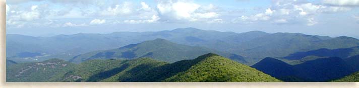
Spring Mountain is located in the northern extremes of Dawson County. There’s an 8.1-mile approach trail to the southern terminus of the Appalachian Trail within Amicalola Falls State Park. The AT winds over the mountaintops of the North Georgia’s Chattahoochee National Forest before heading off into North Carolina’s Nantahala and Pisgah National Forest. The accompanying photo is the southeastern view of the AT terrain over the southern most Blue Ridge Mountains, viewed from atop Brasstown Bald.
Even though some diehard hikers take on the whole 2,100-mile trek most day hikers pickup the trail at a chosen point and hike several miles while taking in the wilderness experience, with a return trip equally as exciting with opposite views to keep their hike fresh.
There are roadways that cross the Appalachian Trail at several locations throughout the Chattahoochee National Forest; this makes access to the AT convenient and allows hikers to experience different section of the world famous Appalachian Trail with each visit.
Chattahoochee National Forest
North Georgia’s Chattahoochee National Forest in the Blue Ridge Mountains contains 750,000 acres of forest, waterways and mountain lands. The two highest peaks in North Georgia’s Chattahoochee National Forest are Brasstown Bald and Rabun Bald both reaching nearly 5,000 feet above sea level. The majority of all the counties in North Georgia have claim to a foothold or more within the bountiful 750,000 acres of national forest plus state parks.
As the centerpiece of Dawson County’s mountain wilderness areas lies Amicalola Falls State Park with its 6,760-acres of mountain wonderland. Camping, hiking, fishing, mountain biking and more await the arrival of visitors to these ancient eastern North American Mountains for experiences only mountain and wilderness lands can offer.
Dawson Forest Wildlife Management Area
The Dawson Forest Wildlife Management Area lies in the heart of Dawson County containing a 10,130-acre forest owned by City of Atlanta. The Georgia Forestry Commission manages this wildlife management area, forest and waterways. Under stewardship for the city, the commission oversees conservation practices that minimize the damage of both human and natural forces caused to this forest property. These conservation practices assist both wildlife habitats and contribute to clean water along the Etowah River watershed. Under control, cutting and reforesting timber is produce from the Dawson Forest.
Lake Lanier
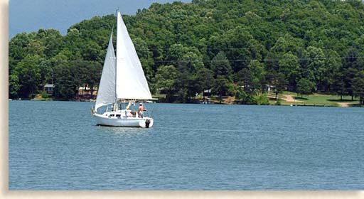 From mountains and forests to valleys and lakes, Dawson County offers a wide range of outdoor fun and recreation. The 39,000-arces of water surface along with the 692-miles of shoreline of Lake Lanier borders five neighboring counties, Hall, Forsyth, Gwinnett, Lumpkin and the southeastern regions of Dawson County.
Lake Lanier is the largest body of fresh water in North Georgia with an estimated 7.5 million visitors each year. Swimming, boating, sailing, skiing, jet skiing, fishing, shoreline parks, camping and lake front homes make Lake Lanier a popular recreation and water reserve.
The hydroelectric generators at Buford Dam produced their first electrical output on June 17, 1957. Of the many waterways that contribute to Lake Lanier’s water base, the lake generally follows the line of the Chattahoochee River both entering and exiting the lake at the dam. Having Lake Lanier in their backyard is a very special attribute to Dawson County’s portfolio.
Kangaroo Conservation Center
Dawson County’s outback country is just that, a nearly perfect “Australian Outback,” except for that barely noticeable northern, southern hemisphere thing.
 Exotic animals are no strangers to the North Georgia Mountains and the plentiful grasslands within the foothills of the Blue Ridge Mountains make a wonderful home for Australia’s big-footed friends, the kangaroo.
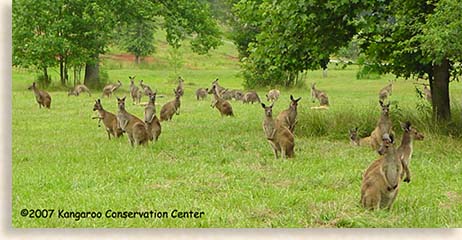
The Kangaroo Conservation Center has been in operation since 1987 and is a member of the Association of Zoos and Aquarium Association, an organization of the highest quality zoos and wildlife facilities in North America.
Residing at the Kangaroo Conservation Center and making their home in the United States are roughly 300 kangaroos. The center maintains eight of the 60 different species of kangaroo that exist today. Of the 8 species represented at the center you’ll find a surprising range of kangaroo sizes, from small rodent size characters called Potoroos to Western Gray kangaroos that weigh 180-pounds. In addition, at the conservation center is a bird sanctuary and reptiles on permanent visa from the Land Down Under.
The Kangaroo Conservation Center mission statement is, “We are dedicated to the 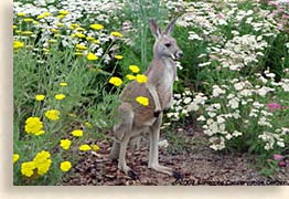 preservation of kangaroo species thru captive breeding and education.” The center has bred and cared for over a dozen different species of marsupials since it’s opening.
The 87-acre wildlife conservation center is only a 1-hour drive from Atlanta and offers a 1-1/2 hour guided tours. The new Fern Valley Trail 1/4-mile is a nature trail through a forest of native trees and rare plant specimens.
There’s a cute gift shop “The Aussie Outpost,” with kangaroo and other Aussie world critters stuff, fun and educational for the kids and adults alike. The minimum age for admission is 2nd grade due to insurance restrictions. Kangaroo Conservation Center provided photos of Center and are their copyright.
From the Foothills to the Mountains Dawson County Georgia is a great convenient escape from the congested world, with excellent shopping, lodging, dining, and outdoor recreation for the whole family, plan a visit today.
| Amicalola State Park | Waterfalls in Dawson County | Fishing in Dawson County |
| National Forestry in Dawson County |
Sign up for the Blue Ridge Highlander Newsletter, Messages from the Mountains
to find out first about our new feature stories, road trips and special offers
Your e-mail addresses will not be sold or given away to anyone.
Privacy Policy
Interested in your business being on the Highlander, click here...
Let our visitors tell you about the Highlander...
Click the feathers to go to the Highlander site
map...

Your e-mail addresses will not be sold or given away to anyone.
Let our visitors tell you about the Highlander...
Click the feathers to go to the Highlander site
map...
Highlander Special Interests
Great Mountain Attractions and Destinations Links to All Highlander Advertisers
Blue Ridge Highlander Mountain Emporium Art Gallery Photo Gallery Handmade Products Book Store
Magazine, Virtual Tours and Scenic Road Trips Creative Mountain Classes Just for Kids
Living Green and Eco Friendly in the Mountains Gardening in the Mountains Mountain Recipes
Mountain and Native American History Nathanael O. Smith - Storyteller Mysteries, Myths and Legends in the Mountains
Mountain Cathedral Charities and Fundraisers
Great Mountain Retreats
Adventure - Art - Cooking - Corporate - Family - Friend - Yoga - Wellness - Youth
Learn More About the Towns and Cities in the Mountains
North Georgia Mountains Western North Carolina Mountains
Up Country South Carolina Tennessee River Valley and Mountains
Great Smoky Mountains Blue Ridge Parkway
Move to or Invest in the Mountains
Real Estate - Log Homes - Cabins - Homes - Land - Acreage - Commercial Real Estate
North Georgia Mountain Real Estate Western North Carolina Real Estate
Tennessee River Valley and Smoky Mountain Real Estate
Traveling - Living - Enjoying the Mountains
Log Cabin Rentals - Vacation Rentals - Resorts - Condos - Inns - Hotels - Bed and Breakfasts
North Georgia Mountain Lodging Western North Carolina Lodging Tennessee River Valley Lodging
Plan a Mountain Wedding or Gatherings Conference, Meeting and Retreat Facilities
Vineyards - Wineries - Tasting Rooms Agri-Tourism Farmer's Markets
Yoga Retreats - Spas in the Mountains
Events and Festivals in the Mountains Theatre - Concerts - Mountain Entertainment
Restaurants, Dining and Catering in the Mountains
Shopping in the Mountains Blue Ridge Highlander Mountain Emporium and Art Gallery
Artists, Art Galleries and Art Associations in the Mountains Museums, History and Culture in the Mountains
Family Fun in the Mountains Just for Kids
Adventure and Outdoor Fun in the Mountains
Mountain Adventure Horseback Riding, Stables and Trails Mountain Bike Trails
White Water Rafting and Adventure Zipline - Canopy Tours Fishing in the Mountains
Boating and Marinas Camping and RV Parks ORV Adventures
Scenic Mountain Drives Mountain Golf Courses Mountain Day Use and Picnic Areas
National Parks in the Mountains National Forest Service in the Mountains State Parks in the Mountains
Waterfalls in the Mountains Lakes in the Mountains Rivers, Creeks and Trout Streams in the Mountains
Nature and Wildlife in the Mountains Mountain Birding Hiking Trails in the Mountains
More Information
Home Site Map Advertise on the Highlander Link to the Highlander Contact the Publisher
Legal Privacy Policy Copyright Policy
designed, produced and hosted by

of C. Wayne Dukes and Sherry Bell Dukes. 1996 - 2017, except where otherwise stated. All rights reserved, reproduction,
downloading, and/or duplication of any sort is strictly prohibited, all violations will be prosecuted. Legal Policy.
If you have any questions, or comments, regarding this site, e-mail the Highlander.